| at: |
Burnt Mountain |
Data from David Muse
 show on map
 animate
Trail users:


Elevation Profile
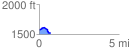
 0.741719 mi
 42.36 ft
 91.93 ft
 -49.57 ft
 2.35 %
GPX Downloads: Track Route
![]()
| at: |
Burnt Mountain |
show on map
animate
0.741719 mi
42.36 ft
91.93 ft
-49.57 ft
2.35 %