| at: |
Burnt Mountain |
Data from David Muse
 show on map
 animate
Trail users:


Elevation Profile
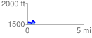
 0.688028 mi
 101.54 ft
 112.34 ft
 -10.79 ft
 3.09 %
GPX Downloads: Track Route
![]()
| at: |
Burnt Mountain |
show on map
animate
0.688028 mi
101.54 ft
112.34 ft
-10.79 ft
3.09 %