| at: |
Burnt Mountain |
Data from David Muse
 show on map
 animate
Trail users:


Elevation Profile
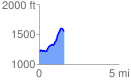
 1.581156 mi
 425.62 ft
 70.47 ft
 355.15 ft
 5.10 %
GPX Downloads: Track Route
![]()
| at: |
Burnt Mountain |
show on map
animate
1.581156 mi
425.62 ft
70.47 ft
355.15 ft
5.10 %