| at: |
Burnt Mountain |
Data from David Muse
 show on map
 animate
Trail users:


Elevation Profile
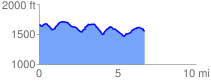
 6.711662 mi
 619.91 ft
 733.50 ft
 -113.58 ft
 2.07 %
GPX Downloads: Track Route
![]()
| at: |
Burnt Mountain |
show on map
animate
6.711662 mi
619.91 ft
733.50 ft
-113.58 ft
2.07 %