| at: |
Fish Hatchery Area |
Data from David Muse
 show on map
 animate
Trail users:


Elevation Profile
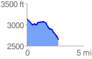
 2.787087 mi
 142.53 ft
 645.49 ft
 -502.96 ft
 4.39 %
GPX Downloads: Track Route
Trailheads:
 Caney Bottom Group Camp
![]()
| at: |
Fish Hatchery Area |
show on map
animate
2.787087 mi
142.53 ft
645.49 ft
-502.96 ft
4.39 %
Caney Bottom Group Camp