| at: |
Fish Hatchery Area |
Data from Positive Flow
 show on map
 animate
Trail users:


Elevation Profile
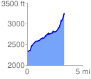
 3.347742 mi
 1141.37 ft
 207.55 ft
 933.82 ft
 6.46 %
GPX Downloads: Track Route
Trailheads:
 Pisgah Fish Hatchery
![]()
| at: |
Fish Hatchery Area |
show on map
animate
3.347742 mi
1141.37 ft
207.55 ft
933.82 ft
6.46 %
Pisgah Fish Hatchery