|
| at: |
Mount Mitchell |
Data from David Muse
 show on map
 animate
Trail users:


Elevation Profile
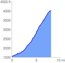
 8.120358 mi
 2628.75 ft
 141.39 ft
 2487.36 ft
 6.13 %
GPX Downloads: Track Route
![]()
|
| at: |
Mount Mitchell |
show on map
animate
8.120358 mi
2628.75 ft
141.39 ft
2487.36 ft
6.13 %