| at: |
Mount Mitchell |
Data from David Muse
 show on map
 animate
Trail users:


Elevation Profile
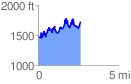
 2.629584 mi
 1131.90 ft
 859.60 ft
 272.30 ft
 8.15 %
GPX Downloads: Track Route
![]()
| at: |
Mount Mitchell |
show on map
animate
2.629584 mi
1131.90 ft
859.60 ft
272.30 ft
8.15 %