|
| at: |
Mount Mitchell |
Data from David Muse
 show on map
 animate
Calling this a road makes liberal use of the word "road". It was once a road, but has become heavily overgrown doubletrack and in some cases singletrack. It's gated. I guess you could get a vehicle down it in the winter.
Trail users:


Elevation Profile
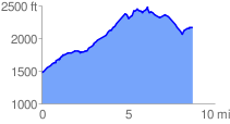
 8.816885 mi
 2088.23 ft
 1394.35 ft
 693.88 ft
 4.49 %
GPX Downloads: Track Route