| at: |
Mount Mitchell |
Data from David Muse
 show on map
 animate
Trail users:


Elevation Profile
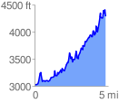
 4.842625 mi
 2756.00 ft
 1483.00 ft
 1273.00 ft
 10.78 %
GPX Downloads: Track Route
![]()
| at: |
Mount Mitchell |
show on map
animate
4.842625 mi
2756.00 ft
1483.00 ft
1273.00 ft
10.78 %