| at: |
Coopers Creek WMA |
Data from David Muse
 show on map
 animate
Trail users:


Elevation Profile
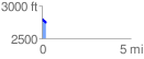
 0.243427 mi
 25.89 ft
 62.42 ft
 -36.53 ft
 4.86 %
GPX Downloads: Track Route
![]()
| at: |
Coopers Creek WMA |
show on map
animate
0.243427 mi
25.89 ft
62.42 ft
-36.53 ft
4.86 %