| at: |
Stoney Creek Ammenity Center |
Data from David Muse
 show on map
 animate
Trail users:

Elevation Profile
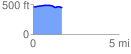
 1.698474 mi
 55.77 ft
 62.83 ft
 -7.05 ft
 0.70 %
GPX Downloads: Track Route
![]()
| at: |
Stoney Creek Ammenity Center |
show on map
animate
1.698474 mi
55.77 ft
62.83 ft
-7.05 ft
0.70 %