| at: |
Talty/Crandall Area Roads |
Data from David Muse
 show on map
 animate
Trail users:


Elevation Profile
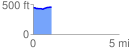
 1.098935 mi
 40.09 ft
 34.65 ft
 5.45 ft
 0.69 %
GPX Downloads: Track Route
![]()
| at: |
Talty/Crandall Area Roads |
show on map
animate
1.098935 mi
40.09 ft
34.65 ft
5.45 ft
0.69 %