| at: |
Talty/Crandall Area Roads |
Data from David Muse
 show on map
 animate
Trail users:


Elevation Profile
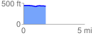
 1.848966 mi
 24.31 ft
 37.57 ft
 -13.25 ft
 0.38 %
GPX Downloads: Track Route
![]()
| at: |
Talty/Crandall Area Roads |
show on map
animate
1.848966 mi
24.31 ft
37.57 ft
-13.25 ft
0.38 %