| at: |
Talty/Crandall Area Roads |
Data from David Muse
 show on map
 animate
Trail users:


Elevation Profile
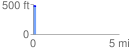
 0.190161 mi
 0.49 ft
 8.96 ft
 -8.46 ft
 0.89 %
GPX Downloads: Track Route
![]()
| at: |
Talty/Crandall Area Roads |
show on map
animate
0.190161 mi
0.49 ft
8.96 ft
-8.46 ft
0.89 %