| at: |
Ocoee Whitewater Center |
Data from David Muse
 show on map
 animate
Trail users:


Elevation Profile
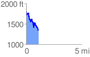
 1.111377 mi
 265.70 ft
 725.00 ft
 -459.30 ft
 12.35 %
GPX Downloads: Track Route
![]()
| at: |
Ocoee Whitewater Center |
show on map
animate
1.111377 mi
265.70 ft
725.00 ft
-459.30 ft
12.35 %