| at: |
Ocoee Whitewater Center |
Data from David Muse
 show on map
 animate
Trail users:


Elevation Profile
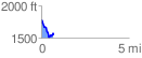
 0.678672 mi
 140.28 ft
 318.53 ft
 -178.25 ft
 8.89 %
GPX Downloads: Track Route
![]()
| at: |
Ocoee Whitewater Center |
show on map
animate
0.678672 mi
140.28 ft
318.53 ft
-178.25 ft
8.89 %