| at: |
Bowmans Island |
Data from David Muse
 show on map
 animate
Trail users:

Elevation Profile
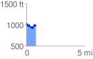
 0.845799 mi
 129.58 ft
 197.81 ft
 -68.24 ft
 4.43 %
GPX Downloads: Track Route
![]()
| at: |
Bowmans Island |
show on map
animate
0.845799 mi
129.58 ft
197.81 ft
-68.24 ft
4.43 %