| at: |
Cedar Hill State Park |
Data from David Muse
 show on map
 animate
Trail users:


Elevation Profile
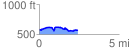
 2.459674 mi
 238.39 ft
 239.96 ft
 -1.57 ft
 1.85 %
GPX Downloads: Track Route
![]()
| at: |
Cedar Hill State Park |
show on map
animate
2.459674 mi
238.39 ft
239.96 ft
-1.57 ft
1.85 %