| at: |
Cedar Hill State Park |
Data from David Muse
 show on map
 animate
Trail users:


Elevation Profile
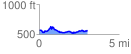
 3.042320 mi
 360.20 ft
 354.27 ft
 5.94 ft
 2.24 %
GPX Downloads: Track Route
![]()
| at: |
Cedar Hill State Park |
show on map
animate
3.042320 mi
360.20 ft
354.27 ft
5.94 ft
2.24 %