| at: |
Northeast Texas Trail |
Data from David Muse
 show on map
 animate
Trail users:


Elevation Profile
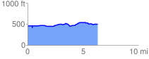
 6.303019 mi
 258.66 ft
 221.85 ft
 36.81 ft
 0.78 %
GPX Downloads: Track Route
![]()
| at: |
Northeast Texas Trail |
show on map
animate
6.303019 mi
258.66 ft
221.85 ft
36.81 ft
0.78 %