| at: |
Serenbe |
Data from David Muse
 show on map
 animate
Trail users:


Elevation Profile
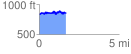
 1.697617 mi
 254.92 ft
 232.48 ft
 22.44 ft
 2.84 %
GPX Downloads: Track Route
![]()
| at: |
Serenbe |
show on map
animate
1.697617 mi
254.92 ft
232.48 ft
22.44 ft
2.84 %