| at: |
Serenbe |
Data from David Muse
 show on map
 animate
Trail users:


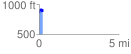
Elevation Profile
 0.205742 mi
 95.70 ft
 74.41 ft
 21.29 ft
 8.81 %
GPX Downloads: Track Route
![]()
| at: |
Serenbe |
show on map
animate
0.205742 mi
95.70 ft
74.41 ft
21.29 ft
8.81 %