| at: |
Serenbe |
Data from David Muse
 show on map
 animate
Trail users:


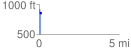
Elevation Profile
 0.102146 mi
 88.06 ft
 79.04 ft
 9.02 ft
 16.33 %
GPX Downloads: Track Route
![]()
| at: |
Serenbe |
show on map
animate
0.102146 mi
88.06 ft
79.04 ft
9.02 ft
16.33 %