| at: |
Carrollton Greenbelt |
Data from David Muse
 show on map
 animate
Trail users:


Elevation Profile
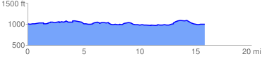
 15.952691 mi
 806.59 ft
 806.59 ft
 0.00 ft
 0.96 %
GPX Downloads: Track Route
Trailheads:
 Hays Mill Park
![]()
| at: |
Carrollton Greenbelt |
show on map
animate
15.952691 mi
806.59 ft
806.59 ft
0.00 ft
0.96 %
Hays Mill Park