| at: |
Chisenhall Fields |
Data from David Muse
 show on map
 animate
Trail users:


Elevation Profile
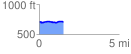
 1.518780 mi
 66.40 ft
 66.44 ft
 -0.03 ft
 0.83 %
GPX Downloads: Track Route
![]()
| at: |
Chisenhall Fields |
show on map
animate
1.518780 mi
66.40 ft
66.44 ft
-0.03 ft
0.83 %