| at: |
Greenbelt Corridor |
Data from David Muse
 show on map
 animate
Trail users:


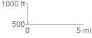
Elevation Profile
 0.069660 mi
 0.39 ft
 4.40 ft
 -4.00 ft
 1.20 %
GPX Downloads: Track Route
Trailheads:
 Greenbelt 428 Park Lot
![]()
| at: |
Greenbelt Corridor |
show on map
animate
0.069660 mi
0.39 ft
4.40 ft
-4.00 ft
1.20 %
Greenbelt 428 Park Lot