| at: |
Ray Roberts Lake State Park - Isle DeBois Unit Ray Roberts Greenbelt |
Data from David Muse
 show on map
 animate
Trail users:


Elevation Profile
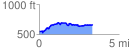
 3.368376 mi
 358.17 ft
 233.30 ft
 124.87 ft
 2.01 %
GPX Downloads: Track Route
Trailheads:
 Bluestem Grove Equestrian LotRay Roberts Greenbelt Lot