| at: |
Ray Roberts Greenbelt |
Data from David Muse
 show on map
 animate
Trail users:


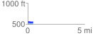
Elevation Profile
 0.459649 mi
 5.38 ft
 8.50 ft
 -3.12 ft
 0.35 %
GPX Downloads: Track Route
![]()
| at: |
Ray Roberts Greenbelt |
show on map
animate
0.459649 mi
5.38 ft
8.50 ft
-3.12 ft
0.35 %