| at: |
Ocala National Forest |
Data from Karlos Bernart
 show on map
 animate
Trail users:


Elevation Profile
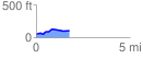
 1.790684 mi
 95.57 ft
 41.80 ft
 53.77 ft
 1.01 %
GPX Downloads: Track Route
![]()
| at: |
Ocala National Forest |
show on map
animate
1.790684 mi
95.57 ft
41.80 ft
53.77 ft
1.01 %