| at: |
Dawson Forest |
Data from David Muse
 show on map
 animate
Trail users:


Elevation Profile
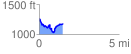
 1.479160 mi
 238.88 ft
 326.49 ft
 -87.61 ft
 4.18 %
GPX Downloads: Track Route
![]()
| at: |
Dawson Forest |
show on map
animate
1.479160 mi
238.88 ft
326.49 ft
-87.61 ft
4.18 %