| at: |
Ocoee Whitewater Center |
Data from David Muse
 show on map
 animate
Trail users:


Elevation Profile
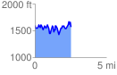
 2.535574 mi
 823.80 ft
 846.70 ft
 -22.90 ft
 6.32 %
GPX Downloads: Track Route
![]()
| at: |
Ocoee Whitewater Center |
show on map
animate
2.535574 mi
823.80 ft
846.70 ft
-22.90 ft
6.32 %