| at: |
Dawson Forest |
Data from David Muse
 show on map
 animate
Trail users:


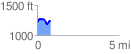
Elevation Profile
 0.849999 mi
 118.82 ft
 114.23 ft
 4.58 ft
 2.65 %
GPX Downloads: Track Route
![]()
| at: |
Dawson Forest |
show on map
animate
0.849999 mi
118.82 ft
114.23 ft
4.58 ft
2.65 %