| at: |
Dawson Forest |
Data from Positive Flow
 show on map
 animate
Trail users:


Elevation Profile
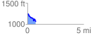
 0.735120 mi
 55.15 ft
 240.27 ft
 -185.12 ft
 6.19 %
GPX Downloads: Track Route
![]()
| at: |
Dawson Forest |
show on map
animate
0.735120 mi
55.15 ft
240.27 ft
-185.12 ft
6.19 %