| at: |
Dawson Forest |
Data from Positive Flow
 show on map
 animate
Trail users:


Elevation Profile
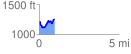
 0.959109 mi
 222.36 ft
 190.78 ft
 31.58 ft
 4.39 %
GPX Downloads: Track Route
![]()
| at: |
Dawson Forest |
show on map
animate
0.959109 mi
222.36 ft
190.78 ft
31.58 ft
4.39 %