| at: |
Tsali Recreation Area |
Data from HikeWNC (HikeWNC.com)
 show on map
 animate
Trail users:


Elevation Profile
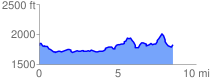
 8.614889 mi
 1833.54 ft
 1785.92 ft
 47.63 ft
 4.03 %
GPX Downloads: Track Route
Trailheads:
 Tsali
Tsali![]()
| at: |
Tsali Recreation Area |
show on map
animate
8.614889 mi
1833.54 ft
1785.92 ft
47.63 ft
4.03 %
Tsali