| at: |
Stone Mountain |
Data from David Muse
 show on map
 animate
Trail users:

Elevation Profile
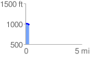
 0.333003 mi
 34.14 ft
 44.55 ft
 -10.41 ft
 2.53 %
GPX Downloads: Track Route
![]()
| at: |
Stone Mountain |
show on map
animate
0.333003 mi
34.14 ft
44.55 ft
-10.41 ft
2.53 %