| at: |
South Oconee National Forest |
Data from David Muse
 show on map
 animate
Trail users:


Elevation Profile
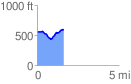
 1.645876 mi
 180.13 ft
 143.51 ft
 36.62 ft
 2.07 %
GPX Downloads: Track Route
![]()
| at: |
South Oconee National Forest |
show on map
animate
1.645876 mi
180.13 ft
143.51 ft
36.62 ft
2.07 %