|
| at: |
North Oconee National Forest |
Data from David Muse
 show on map
 animate
Trail users:


Elevation Profile
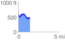
 1.432996 mi
 212.10 ft
 341.14 ft
 -129.04 ft
 4.51 %
GPX Downloads: Track Route
![]()
|
| at: |
North Oconee National Forest |
show on map
animate
1.432996 mi
212.10 ft
341.14 ft
-129.04 ft
4.51 %