| at: |
West Georgia Pinhoti Johns Mountain WMA |
Data from David Muse
 show on map
 animate
The USFS map shows this trail as being part of FS254 but the USFS GIS shows FS254 turning away to the east, south of this trail.
Trail users:


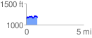
Elevation Profile
 0.991561 mi
 135.06 ft
 128.82 ft
 6.24 ft
 2.58 %
GPX Downloads: Track Route