|
| at: |
Iron Mountain/Sumac Creek |
Data from David Muse
 show on map
 animate
Trail users:


Elevation Profile
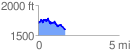
 1.683378 mi
 283.14 ft
 380.78 ft
 -97.64 ft
 4.28 %
GPX Downloads: Track Route
![]()
|
| at: |
Iron Mountain/Sumac Creek |
show on map
animate
1.683378 mi
283.14 ft
380.78 ft
-97.64 ft
4.28 %