| at: |
Iron Mountain/Sumac Creek |
Data from Josh Bailey
 show on map
 animate
Trail users:


Elevation Profile
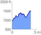
 3.817577 mi
 1183.16 ft
 661.67 ft
 521.49 ft
 5.87 %
GPX Downloads: Track Route
Trailheads:
 Cottonwood Patch Campground
![]()
| at: |
Iron Mountain/Sumac Creek |
show on map
animate
3.817577 mi
1183.16 ft
661.67 ft
521.49 ft
5.87 %
Cottonwood Patch Campground