|
| at: |
South Oconee National Forest |
Data from David Muse
 show on map
 animate
Trail users:


Elevation Profile
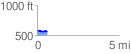
 0.615561 mi
 20.95 ft
 36.56 ft
 -15.62 ft
 1.12 %
GPX Downloads: Track Route
![]()
|
| at: |
South Oconee National Forest |
show on map
animate
0.615561 mi
20.95 ft
36.56 ft
-15.62 ft
1.12 %