|
| at: |
Iron Mountain/Sumac Creek |
Data from David Muse
 show on map
 animate
Trail users:


Elevation Profile
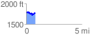
 0.804632 mi
 163.79 ft
 183.16 ft
 -19.37 ft
 4.31 %
GPX Downloads: Track Route
![]()
|
| at: |
Iron Mountain/Sumac Creek |
show on map
animate
0.804632 mi
163.79 ft
183.16 ft
-19.37 ft
4.31 %