|
| at: |
Johns Mountain WMA |
Data from David Muse
 show on map
 animate
Trail users:


Elevation Profile
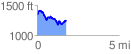
 1.783589 mi
 349.00 ft
 442.46 ft
 -93.46 ft
 4.70 %
GPX Downloads: Track Route
![]()
|
| at: |
Johns Mountain WMA |
show on map
animate
1.783589 mi
349.00 ft
442.46 ft
-93.46 ft
4.70 %