|
| at: |
Johns Mountain WMA |
Data from David Muse
 show on map
 animate
Trail users:


Elevation Profile
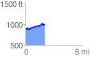
 1.742838 mi
 215.79 ft
 94.81 ft
 120.97 ft
 2.34 %
GPX Downloads: Track Route
![]()
|
| at: |
Johns Mountain WMA |
show on map
animate
1.742838 mi
215.79 ft
94.81 ft
120.97 ft
2.34 %