|
| at: |
North Oconee National Forest |
Data from David Muse
 show on map
 animate
Trail users:


Elevation Profile
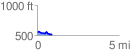
 0.949061 mi
 70.86 ft
 116.42 ft
 -45.56 ft
 2.32 %
GPX Downloads: Track Route
![]()
|
| at: |
North Oconee National Forest |
show on map
animate
0.949061 mi
70.86 ft
116.42 ft
-45.56 ft
2.32 %