|
| at: |
Johns Mountain WMA |
Data from David Muse
 show on map
 animate
Trail users:


Elevation Profile
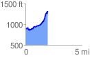
 1.989154 mi
 573.95 ft
 144.48 ft
 429.47 ft
 5.46 %
GPX Downloads: Track Route
![]()
|
| at: |
Johns Mountain WMA |
show on map
animate
1.989154 mi
573.95 ft
144.48 ft
429.47 ft
5.46 %