|
| at: |
Iron Mountain/Sumac Creek |
Data from David Muse
 show on map
 animate
Trail users:


Elevation Profile
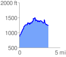
 3.566013 mi
 1109.08 ft
 748.97 ft
 360.12 ft
 5.89 %
GPX Downloads: Track Route
![]()
|
| at: |
Iron Mountain/Sumac Creek |
show on map
animate
3.566013 mi
1109.08 ft
748.97 ft
360.12 ft
5.89 %