|
| at: |
North Oconee National Forest |
Data from David Muse
 show on map
 animate
Trail users:


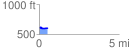
Elevation Profile
 0.532177 mi
 22.17 ft
 26.32 ft
 -4.15 ft
 0.94 %
GPX Downloads: Track Route
![]()
|
| at: |
North Oconee National Forest |
show on map
animate
0.532177 mi
22.17 ft
26.32 ft
-4.15 ft
0.94 %